
Students at the forefront
On the non-commercial front, a recent and revolutionary project that must be discussed is ArduSat, the first open source nanosatellite developed by Nanosatisfi LLC, an aerospace company founded by four graduate students in the US in 2012. Based on the CubeSat standard, Ardusat contains a set of Arduino boards and sensors. ArduSat was successfully launched this August, with a stated goal of providing people open access to space! Priya Kuber, managing director of Arduino India, says, “ArduSat is an Arduino satellite wherein Arduino users can test their code in space. It is exciting to know that now Indian students would be able to have the same access to space! ArduSat has tied up with Dhruva Space India, and we are partnering with them to teach space-oriented experiments in a fun and educative way (http://www.spaceschool.co.in).”
“A few universities have developed small satellites with the help of ISRO. SRMSAT and YOUTHSAT, launched by ISRO’s launch vehicles during 2011, are examples,” John points out.
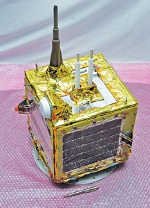
Anna University successfully launched the first student-built Indian satellite in 2009. Called Anusat, this is a 60×60×60cm cube-shaped microsatellite that weighs 38 kg. The spin-stabilised satellite operates at 40W power using a lithium-ion (Li-ion) battery and a body-mounted solar panel with GaAs cells, and communicates in the VHF/UHF band. It orbits at a height of 547 km with a 41-degree inclination and a period of 120 minutes, and is visible over Chennai four times a day, for around 10 minutes each time. Its primary payload comprises store and forward data communication (FSK 1.2kbps) while auxiliary payloads include technology validation of GPS receiver, a MEMS magnetometer and MEMS gyroscope.

Another example, YOUTHSAT, is the culmination of joint efforts by Indian and Russian students. It is one of the three small satellites that ISRO launched in 2011. It has a lift-off mass of 92 kg, and carries three payloads for the investigation of the composition, energetics and dynamics of the earth’s upper atmosphere. It has an orbit period of 101.35 minutes and an inclination of approximately 98 degrees. It features a three-axis body stabilised using sun and star sensors, a miniature magnetometer, miniature gyros, micro reaction wheels and magnetic torquers. It also has a solar array generating 230 watts and one 10.5Ah Li-ion battery as well as a paraffin actuator-based solar panel hold-down and release mechanism.
SRMSAT is a nanosatellite developed by Tamil Nadu-based SRM University under ISRO’s guidance. It weighs 10.9 kg and attempts to understand global warming and pollution levels in the atmosphere by monitoring carbon dioxide and water vapour. The satellite uses a grating spectrometer to observe the absorption spectrum over the 900nm to 1700nm infrared range.
Another exciting nanosatellite in this class is Jugnu, developed by IIT-Kanpur under ISRO’s guidance. The 3kg satellite carries an indigenously developed camera system for imaging the earth in the near infrared region and test image processing algorithms, as well as an indigenous MEMS-based inertial measurement unit (IMU).
From disaster recovery to grain pricing
Small satellites, including micro and nano ones, have a vast array of applications. “Remote sensing, propagation experiments, emergency store and forward communication, validation of new technologies in the fields of power systems, control techniques, propulsion systems, etc, are some of the applications where microsatellites can be of good use,” explains John. “It is also true that a shift towards microsatellites facilitates universities and industries to develop and validate new technologies,” he says.
Apart from government and research uses, it is interesting to note the potential for the commoditisation of small satellites, with earth imagery beginning to be recognised as a useful tool by other industries as well. According to Schingler of Planet Labs, “We see this industry becoming more important to both commercial and non-profit players. Receiving fresh data about the earth is a new capability that we haven’t seen before. The applications for our data are limitless, and every day when we read a newspaper, we find more use cases. For now, we are very focused on achieving our milestones.” He adds, “Industries that can benefit from the information include disaster monitoring and response, agriculture, real estate and construction, environmental monitoring and stewardship, financial services, insurance, scientific and academic research, conservation, humanitarian causes and mapping. We hope our data will help farmers optimise crop yields and conservationists monitor deforestation.”
[stextbox id=”info” caption=”Can a commercial smartphone be converted into a satellite?”]
In April this year, NASA launched three ‘smartphones’ into orbit. Known as PhoneSats, these were part of NASA’s ongoing mission to determine whether a consumer-grade smartphone can be used as the main flight avionics of a low-cost satellite. NASA engineers took a Google-HTC Nexus One smartphone running the Android operating system, and added satellite-necessities that a phone does not have, such as a larger Li-ion battery, a more powerful radio, and so on. Texting and calling facilities were disabled. And after some ingenious work, the off-the-shelf PhoneSats were ready with fast processors, versatile operating systems, multiple miniature sensors, high-resolution cameras, GPS receivers and several radios. The total cost of the components of all three satellites in the PhoneSats project was less than $7000 as the engineers relied on commercial hardware design and stuck to minimal mission objectives. The smartphones were housed in a standard CubeSat structure, and acted as the satellite’s onboard computer.
The sensors monitored the health of the unit, while the camera kept taking pictures, all of which were relayed back to earth for a period of two weeks, the estimated life of the satellites. The communications between the base station and the satellites were all available on the Web for microsat enthusiasts to monitor. After the estimated two weeks, the satellites dived towards the earth and burnt up, as expected. The team is now working on lower-cost prototypes, scheduled to be launched by the end of the year.
[/stextbox]