
In modern telecom infrastructure deployments, optical fibre cable (OFC) is typically laid in underground trenches, where maintaining the specified trench depth is critical for safety, long-term reliability, and protection against accidental damage. Traditionally, excavation is carried out manually or using trenching machines, while trench depth is measured with tapes or scales and the running length is recorded separately. This conventional method is labour-intensive, time-consuming, and susceptible to human error.
POC Video Tutorial
To address these limitations, a portable ultrasonic trench depth and location logger system is proposed. It provides an automated, accurate, and user-friendly solution for real-time field measurements. The system uses an ultrasonic depth sensor, such as the HC-SR04, mounted on a handheld frame to measure trench depth without physical contact. In addition, a GPS module captures precise latitude and longitude coordinates, enabling the geotagging of every measurement.
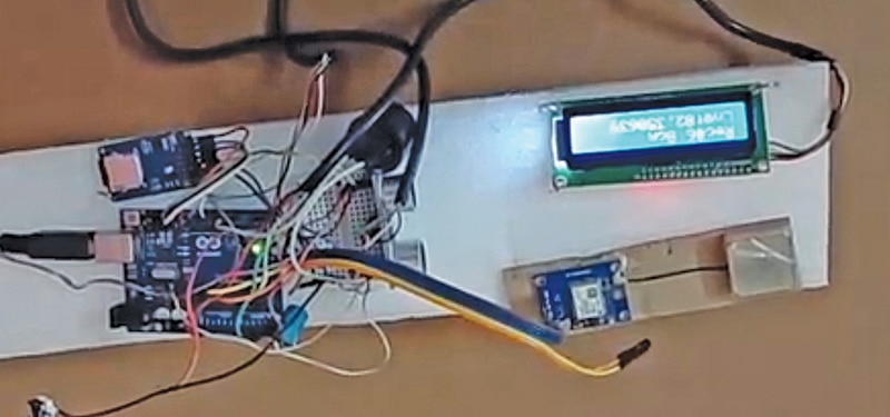
At the core of the system, an Arduino Uno synchronises depth measurements with GPS data and logs them onto an SD card in CSV format for easy analysis and visualisation. The recorded data can also be converted into KML format for use in mapping applications such as Google Earth. Fig. 1 shows the author’s prototype.

For enhanced usability, a push-button switch allows the operator to initiate data logging, while a buzzer provides audible feedback each time a reading is successfully recorded. This improves operational reliability and field usability. The logged data can be further processed to generate depth profiles, reports, and geospatial maps, enabling efficient monitoring and documentation of OFC trench-laying operations.
The components required to build this system are listed in Bill of Materials table.

| Bill of Materials | ||
| Components | Description/Function | Quantity |
| Arduino Uno R3 | The main microcontroller board that controls all peripherals | 1 |
| HC-SR04 ultrasonic sensor | Measures trench depth (distance to bottom) | 1 |
| NEO-6M GPS module | Provides latitude and longitude for location tagging | 1 |
| I2C 16×2 LCD display | Displays distance, GPS data, and record number | 1 |
| Micro SD card module (SPI) | Logs data (distance, GPS) to SD card | 1 |
| Push button (tactile switch) | Triggers manual data logging when pressed | 1 |
| Active buzzer (5V) | Provides audio feedback when data is logged | 1 |
| Power bank (5V USB output) | Portable power supply for field use | 1 |
| Connecting wires (male-male, male-female) | For all interconnections between modules | 1 |
| Breadboard/PCB mount | For prototyping or mounting modules | 1 |
| Mounting setup/handle frame | Ultrasonic sensor facing downward into the trench | 1 |
Circuit and working