- Enables ground movement monitoring with the help of data obtained through satellite image analysis in a cost and time effective manner
- Can be applied in many land risk management projects such as construction projects, airport maintenance projects and subway development projects, among others
 Synspective Inc, a Japanese company providing satellite data and derived solutions, using small-sized SAR (Synthetic Aperture Radar) satellites, launched its first “Land Displacement Monitoring” service, enabling ground movement monitoring in millimetres, obtained through image analysis of SAR satellites data.
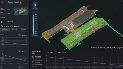
The “Synspective Land Displacement Monitoring” service originates from InSAR analysis that is capable of detecting timely vertical land displacement, in millimeters, over a wide area. The service claims to enable periodical observation and understanding of land subsidence and deformation.

About the service
Synspective’s new service claims to be cost and time effective, when compared to the traditional observation and control techniques associated with these ground change risks. The service’s expected use is multifaceted and can be applied in many land risk management projects such as construction projects, airport maintenance projects, and subway development projects, among others. Monitoring in remote areas/sites can be extremely relevant in disaster struck areas where human access is restricted or dangerous, or where social movement is restricted due to the recent COVID-19 virus impact. The User-friendly UI/UX enables users to intuitively understand the analysis results without any prior knowledge of satellite data.
InSAR & Synspective’s own SAR data
InSAR, better known as Interferometric Synthetic Aperture Radar, is a technical method for investigating changes in the ground surface. Changes in the ground surface can be detected by processing the observation data of the AOI multiple times under the same conditions. This makes it possible to detect millimetre-scale deviations on the ground surface over a wide area without installing a device onsite.
Synspective plans to launch its own small SAR satellite “StriX-α”, in 2020. In the near future, it can provide solutions with higher frequency and stable monitoring by use of data obtained from the SAR satellite constellation.
“We’ll develop user-owned data”
Synspective’s Solutions Development Department General Manager, Tomoyuki Imaizumi, commented “”Land Displacement Monitoring” will be Synspective’s first official service. We plan to continuously improve the service based on user feedback and increase the frequency of monitoring by utilizing our own satellite constellation. We are also planning to develop services that combine user-owned data based on this service.”
Capability and functionality of this service were tested through preliminary utilization projects with several companies and organizations, including through participation in a PoC project by Singapore Land Authority, a statutory board under the Ministry of Law of Singapore. Through the insights and lessons learned from this PoC project, further utilization models were developed. This project also provided Synspective with feedback for improvements to the service, which has been incorporated in the current release.