


Originally used in military applications, an unmanned aerial vehicle (UAV), or a drone, is today found almost everywhere. According to ‘UAV Payload and Subsystems Market: Global Industry Trends, Share, Size, Growth, Opportunity and Forecast 2019-2024’ report, the market is expected to reach a value of US$ 11.6 billion by 2024, at a compound annual growth rate (CAGR) of 7.3 per cent during 2019-2024.
Established in 2018 to offer a complete UAV ecosystem, Hyderabad-based Terra Drone India Pvt Ltd provides end-to-end drone solutions based on customer needs. It works mainly on UAV engineering, geographic information system (GIS) solutions, videography and software development. It is an associate company of Japan’s Terra Drone Corp. founded in 2016, at a time when the Japanese government was promoting i-Construction initiative under which construction sites would integrate information and communications technology (ICT) to increase productivity.

The startup is completely indigenous, thus boosting the Indian market. Regarding government support, Prateek Srivastava, chief executive officer, Terra Drone India, says, “Terra Drone India has found support from the current government, especially in terms of single-window registration, ease of doing business and bringing proven foreign technologies to India through initiatives like Startup India and Make in India. Department for Promotion of Industry and Internal Trade (DPIIT) and National Small Industries Corp. (NSIC) have helped startups like us to operate on par with established players in the drone industry. The policy of Telangana state government to support locally-based new-age technology companies such as Terra Drone India has also been very encouraging.”
Hardware products have been designed to cater to the surveying needs of their clients, and include Terra Wing, Terra SLAM and Terra LiDAR (light detection and ranging) system. The range of their operations is 7km. Communication medium for the drones is radio telemetry, which allows the operator to accurately monitor the conditions while flying.
Terra Wing is a dedicated survey-grade, fixed-wing unmanned aerial system (UAS) designed to cover large areas in a short time. It has a 24/42MP camera, 9000mAh battery and a speed range of 10m/s to 25m/s. It finds application in infrastructure inspection, agriculture and so on.
Terra SLAM is a dust- and water-resistant solution built for underground mines. It uses lithium-polymer batteries, and has a flight time of up to twenty minutes.
Terra LiDAR uses pulsed laser light to attain an accuracy of 3cm to 5cm, necessary to provide high-definition 3D models. It finds use in plant height assessment, topographic mapping, digital preservation and the like.
Sharing how the pricing is done, Srivastava says, “Since we are into the services industry, pricing varies from project to project. We also help clients procure drones and related sensors, if required, but the price again depends on the scope of work.”
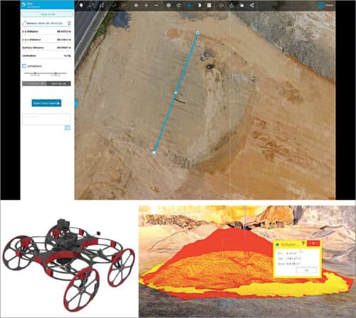
Desktop version of Terra Mapper, the data processing and photogrammetric software developed to speed up the drone services, has recently been launched in India. The user has to upload UAV data to let the software process it and generate results like volume estimation, digital terrain models and contour lines. It is available at an affordable price with discounts for non-profit organisations and educational institutions.
With more than 25 branches globally, the company serves both government and private institutions in a number of sectors such as construction, electricity, energy, and oil and gas.
Talking about the company’s future plans, Srivastava says, “We are actively looking to support the government’s Smart Cities initiatives through intelligent data acquisition and analytics. For example, transport ministry under Nitin Gadkari has fixed a target to build 40km of roads per day. This kind of growth is not possible without using cutting-edge technologies in every sphere, right from planning and execution to maintenance. Terra Drone India’s smart data analytics has the power to act as a key decision support system for stakeholders across industries.”