






What if geological anchors could sense impending landslides? Embedded strain sensors and IoT intelligence enable earlier warnings, reducing risks to lives and infrastructure.
Landslides remain one of the most destructive geotechnical hazards in hilly or mountainous areas. Landslides are triggered by precipitation, seismic activity, or changes in groundwater levels, leading to loss of life, damage to infrastructure, and long-term economic implications. Traditional early warning systems often depend heavily on surface displacement markers, inclinometers, rainfall thresholds, or satellite-based remote sensing. Although useful, they are usually unsuitable for detecting internal stress redistribution or subsurface deformation that occurs before catastrophic slope collapse.
An early warning system
A newly developed Internet of Things (IoT)-enabled landslide early warning system using smart geological anchors with embedded strain-sensing electronics tackles the gap directly by analysing the mechanical behaviour occurring beneath the soil and rock mass in the subsurface. Rather than considering structural anchors as inert reinforcing structures, the system converts them into intelligent sensing nodes that can support real-time deformation monitoring and predictive failure evaluation.
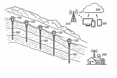
The key idea: turning anchors into sensors
Geological anchors and rock bolts are widespread in slope stabilisation. Traditionally, they are only used to transfer tensile forces to stable strata. Today’s system incorporates embedded strain-sensing electronics through these anchors, resulting in a dual-functioning hardware system.
Each smart geological anchor comprises:
- A high-strength anchor body bonded to surrounding soil or rock
- An embedded strain sensor array
- Signal conditioning and digitisation circuitry
- A microcontroller for local processing
- A wireless communication module
- A low-power energy management unit
Integrating electronics into the physical structure, this system can directly measure axial strain, bending strain, and displacement resulting from ground movement.
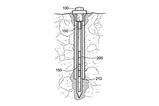
Fig. 2: A cross-sectional view of a smart geological anchor (100) installed within a soil or rock mass
Why monitoring subsurface matters
Often, surface cracks and visible deformation only appear after moderate or severe slope instability. Rainfall-based alerts often cause false alarms because rainfall alone does not necessarily indicate mechanical failure.
However, this system looks more closely at the mechanical deformation inside a slope mass. Progressively accumulating internal strain, which is generally the earliest sign of failure, is detected well before any visible warning signs appear.
This direct subsurface sensing procedure is associated with a significant enhancement in prediction accuracy and reduces false positives in environmental proxy-based systems.
Multi-axis strain sensing for complex failure modes
Landslides are seldom one-way events. They may occur simultaneously with rotational slips, lateral shear, and multiple stress states. In order to handle this issue, the system provides multi-axis strain measurement, with various sensing elements centred around the anchor body.
This allows detection of the following:
- Axial tension or compression
- Lateral bending
- Rotational deformation
- Concentration of stress due to shear
Extensive strain mapping can be used to enhance the characterisation of progressive slope failure.
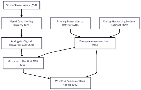
Fig. 3: The internal electronic architecture of the smart geological anchor
Embedded edge intelligence
A microcontroller in each anchor performs local signal processing. Raw strain samples are amplified, filtered, digitised, and calibrated prior to transmission.
The local pre-processing has several benefits:
- Shortened data bandwidth
- Noise filtering at the source
- Adaptive sampling according to deformation patterns
- Overall lower power consumption
This ‘edge intelligence’ improves performance in isolated and bandwidth-starved environments.
IoT communication and cloud analytics
Each smart anchor transmits processed data wirelessly using low-power wide-area communication technologies such as LoRa or Narrowband Internet of Things (NB-IoT).
Several anchors positioned along a slope are used to develop a distributed sensing network. It aggregates data from these nodes at an edge gateway and sends it to a cloud-enabled monitoring platform for centralised insight.
There are two analytical methods used at cloud scale:
- Threshold-based analysis: Identifies strain values that exceed pre-defined safety limits.
- Trend-based failure prediction: Identifies accelerating deformation patterns associated with progressive slope instability.
When instability conditions are detected, automated notifications are sent to authorities via dashboards, mobile alerts, or disaster management tools.
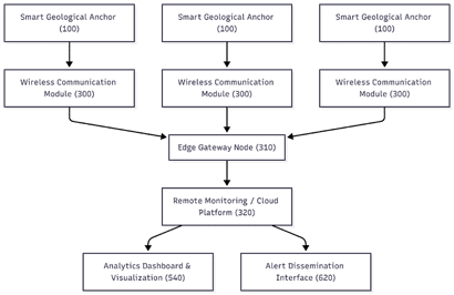
Fig. 4: A communication and IoT data flow architecture of the landslide early warning system
Low-power, long-term field operation
Slope monitoring mechanisms are frequently deployed in remote locations without a reliable power supply. To address this, the system includes:
- High-capacity primary batteries
- Smart power scheduling and sleep mode options
- Optional energy harvesting modules
Dynamic duty cycling allows multi-year independent operation with minimal maintenance.
Advantages over conventional systems
From the point of view of conventional landslide monitoring methods, the system provides:
- Direct subsurface mechanical sensing
- Reduced false alarms
- Reinforcement and monitoring integration into a single unit
- Distributed and scalable deployment
- Real-time remote analytics
- Autonomous long-term operation
By embedding intelligence into structural anchors, the system eliminates the need for dedicated borehole instrumentation and minimises installation complexity.
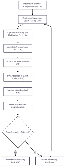
Fig. 5: A method flowchart for landslide early warning
Tech snapshot
- Technology Base: Smart load-bearing geological anchors
- Sensing Parameters: Axial strain, bending strain, displacement
- Processing Unit: Embedded microcontroller with local edge intelligence
- Communication: LoRa / NB-IoT / Cellular Low-Power Wide-Area Network (LPWAN)
- Analytics: Threshold-based and trend-based failure prediction
- Power System: Battery-powered with optional energy harvesting
- Deployment Mode: Distributed multi-anchor network
- Target Applications: Highways, railways, mining slopes, dams, and natural hillsides
Application areas
The system is especially suited to the following applications:
- Mountain highways and railway corridors
- Tunnel portals and retaining walls
- Open-pit mining and quarry operations
- Dams and reservoir slopes
- Urban infrastructure in hilly terrain
- Remote disaster-prone regions
By building on existing anchoring practices, its use can enhance conventional slope stabilisation methods while remaining relatively inexpensive.
Towards predictive disaster mitigation
As atmospheric variability in rainfall and seasonal variations in extreme weather increase due to climate change, landslide frequency is expected to rise. Using this data, early identification of internal deformation mechanisms can greatly reduce casualties and infrastructure damage.
This smart geological anchor system represents a paradigm shift away from reactive disaster response towards proactive risk mitigation by adopting a hybrid of structural reinforcement, embedded strain sensing, wireless IoT connectivity, and predictive analytics. As smart infrastructure and digital monitoring continue to progress, even underground structural elements may become the smart guardians of public safety.
By: Jawaaz Ahmad and Irfan Maqbool Bhat
Jawaaz Ahmad is an innovation practitioner and patent professional with over five years of experience in intellectual property and applied technology design. Associated with the Design Innovation Centre at the Islamic University of Science and Technology (IUST), he has filed more than 100 patent applications, including several granted patents. His work focuses on practical engineering solutions in electronics, renewable energy, disaster mitigation, and smart infrastructure.
Irfan Maqbool Bhat is associated with the Centre for Disaster Risk Reduction at the Islamic University of Science and Technology (IUST), Awantipora. His research focuses on geotechnical risk assessment, slope stability, landslide monitoring technologies, and infrastructure safety in mountainous regions.
The Design Innovation Centre (IUST) is a government-supported innovation hub dedicated to developing practical and scalable technology solutions through interdisciplinary research, prototyping, and intellectual property generation.


