


Let us take a look at the technological trends in lidars and what the future holds for this amazing technology.
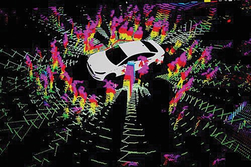
Light detection and ranging, known as lidar, or laser imaging, is a remote sensing technology that uses laser beams to measure distances to objects and creates detailed 3D maps of an environment. The lidar system consists of a laser, a scanner, and a detector. Lidar is a very crucial component in a wide variety of applications, including autonomous vehicles, mapping and surveying, construction, etc. And as with any other important technology, the pace of development in lidar technology is just mind-boggling.
A lot of new lidar modules, sensors, and platforms have been released in the past year, which offer improvements and new features. So, let us look at the technological trends in lidars and what the future holds for this amazing technology. The latest tech trends in lidar technology include:
- Real-time adaptive perception
- Longer range
- More lidar sensors in a lidar module
- Wider field of view
- Faster object detection
- Solid-state lidars
- Improvement in accuracy
- Improvement in dark object detection
- DSP based lidar
- Digital beam steering
- Software definable lidar
Real-time adaptive perception
The latest lidar modules now feature an adaptive perception, which is the ability of lidar systems to adjust their perception parameters based on changing environmental conditions in real time. The performance of lidar systems can be affected by factors such as weather conditions, lighting, and the reflectivity of the surrounding objects.
Adaptive perception algorithms in lidar systems can dynamically adjust the lidar’s parameters, such as laser power, range, and scan rate, based on the changing environment to optimise the performance of the system. For example, if the lidar is operating in foggy conditions, the system can reduce the laser power and increase the scan rate to improve the accuracy of the measurements.
Adaptive perception is particularly important for lidar systems used in autonomous vehicles, where the system must operate in a wide range of environmental conditions while maintaining accurate and reliable perception. By adjusting its parameters in real time, an adaptive perception lidar system can improve the safety and efficiency of autonomous vehicles by providing reliable and accurate environmental information. Velodyne Alpha Prime, Ouster OSDome, and Rev 7 lidar are some of the lidars with real-time adaptive perception.
Better range
The lidar technology has been improving and there’s a common trend of lidar having a higher range. Lidars such as RIEGL VZ-4000 can detect objects up to a range of 4,000 metres. Lidar modules for autonomous vehicles had a much lower range, but newer lidars like Aeries II offer a range of up to 500 metres. Vista-X120 or lidars featuring the Ouster REV7 sensors can offer a range of over 200 metres for autonomous vehicle applications.
To improve the detection range of lidars, manufacturers have increased their power and sensitivity. A higher range in lidar provides several advantages for various applications. It helps detect objects that are farther away from the sensor and thus reduce the risk of collisions. Moreover, the higher range can cover a larger area in a single scan, which can reduce the time required to scan an entire environment and provide more comprehensive coverage. A higher range also enables improved mapping accuracy. Furthermore, the higher range is useful for applications such as autonomous vehicles, robotics, and industrial automation.
More lidar sensors in a single module
Newer lidar modules feature multiple sensors. More sensors in each module offer advantages like improved coverage, redundancy, better accuracy, and a lower cost. Velodyne HDL-32E features 32 laser sensors while Ouster OS-1 packs 64 laser sensors in it. Having multiple sensors allows for a more comprehensive view of the environment. By placing sensors at different angles or heights, the system can obtain a more complete 360-degree view of the surrounding area.
Higher number of sensors is particularly important in safety-critical applications, such as autonomous vehicles, where any failure of the sensor system could have serious consequences. Using multiple sensors can also improve the accuracy of the system. By combining the data from multiple sensors, the system can filter out noise and errors in individual sensor readings, resulting in a more accurate overall measurement.
Another advantage of having multiple sensors is that it can allow use of lower-cost sensors that may not provide the same level of performance individually as more expensive sensors. But by combining multiple lower-cost sensors, the system can achieve similar or better performance at a lower overall cost.
Solid-state lidars
Lidar technology is used in many harsh and difficult applications, including UAVs, vehicles, and even underwater search and mapping applications. To enhance the longevity of the devices, the newer lidars have fewer moving parts.
Solid-state lidars do not having moving parts, which makes them more reliable and durable. Moreover, solid-state lidars are typically smaller and lighter, and have higher efficiency. They also require lesser energy to work. Compared to mechanical spinning lidars, solid-state lidars are cheaper to manufacture.
But one of the main drawbacks of solid-state lidars is that they have narrower field of view. Some examples of solid-state lidars are Velarray M1600, Opsys SP3C, and LeddarSteer.
Wider field of view
The lidar manufacturers are now opting for lidar modules with a wider field of view. The wider field of view is advantageous for many applications as it allows more comprehensive and detailed scanning of the environment. It offers better coverage in a single scan, which can reduce the time required to scan an entire environment and provide more comprehensive coverage.
Moreover, the wider field of view allows for better object detection. It also offers better accuracy and resolution of 3D maps generated by lidar systems, which can be useful for applications such as autonomous vehicles, robotics, and industrial automation. For vehicles, a larger field of view can minimise blind spots that may be present with narrower sensors, which can increase situational awareness and improve safety.
However, a wider field of view may come with tradeoffs in terms of resolution, accuracy, and cost, depending on the specific lidar system and application requirements. Some lidars with a wider field of view are Velodyne Alpha prime, ML-30s+, Vista-X120, XenomatiX, Velarray M1600, OSDome, and Aeries II.
Faster object detection
Lidars are getting faster with the development of new technologies and advancements in hardware and software. Lidar sensors like XenomatiX, ML-30s+, Rev 7, Velarray M1600, Opsys, and LeddarSteer provide faster data output. A faster lidar sensor can capture more data points in a shorter amount of time, which can be crucial for real-time applications, such as autonomous driving.
The development of solid-state lidar technology is one of the key drivers of the increased speed of lidar systems. Another factor driving the faster development of lidar sensors is the more powerful and efficient data processing algorithms. As lidar sensors capture larger amounts of data, more advanced software algorithms are needed to process and analyse this data in real time, allowing the system to make decisions and take actions quickly and accurately.
| Various applications of Lidar |
Autonomous vehicles. Used for sensing the surroundings, making it possible for driverless vehicles to avoid collisions and navigate safely.Mapping and surveying. Lidar is used extensively in cartography and surveying applications to create detailed 3D maps of terrain, buildings, and other features. Agriculture. Lidar is used in precision agriculture to optimise crop yield and reduce waste. Infrastructure inspection. Lidar is used to detect small defects in the surface of bridges, dams, and pipelines. Archaeology. Lidar is used in archaeology to create detailed 3D models of historical sites and artefacts, as it can help uncover hidden features and structures that may not be visible to the naked eye. Security and surveillance. Lidar is used in security and surveillance applications to detect and track moving objects in real time. It can also be used to create 3D models of indoor and outdoor environments, allowing security personnel to identify potential threats and vulnerabilities. |
Improvement in accuracy
Lidar sensors are becoming more accurate in terms of their ability to measure the distance between the sensor and surrounding objects, as well as their ability to capture more detailed information about the environment. Some lidars with improved efficiency are Ouster REV7 lidar, LeddarSteer, and ML-30s+.
One of the key factors driving the improvement in lidar accuracy is the development of higher-resolution sensors. Lidar sensors with higher resolution can capture more data points per scan, which allows for more detailed and accurate 3D maps of the environment. Furthermore, the improvement of advanced algorithms for processing lidar data, machine learning, and other advanced techniques to analyse lidar data are one of the main reasons for the improved accuracy of the lidars.
The post-processing, which corrects errors caused by factors such as sensor noise, environmental interference, and other sources of noise, have also improved and resulted in higher accuracy of lidar sensor.
Improvement in dark object detection
The newer lidar systems are more capable of working in dark environments than the older systems. One reason for this is the development of technologies that improve the sensitivity of lidar sensors to low levels of light. Ouster REV7 lidar sensor employs back-side illumination technology to improve night imaging. Lidars such as Cepton Vista-X120 use sophisticated signal processing techniques to filter out the noise and improve the quality of data captured in low light conditions.
The newer lidar sensors are now capable of detecting and measuring light levels as low as a few photons, which enables them to operate in near-total darkness. Another factor is the development of systems that use multiple sensors and data sources to create a more comprehensive view of the environment.
Some lidar manufacturers are developing algorithms and software that can compensate for low light conditions and improve the accuracy of measurements. While, overall, lidar systems still rely on some level of ambient light to operate, newer systems are becoming more capable of working in dark environments, which makes them more suitable for applications such as autonomous vehicles, surveillance, and search and rescue operations.
DSP based lidar
A lot of new lidar systems employ a digital dignal processor (DSP) to process the signals received by the sensor. ConnX DSP and Cepton Vista-X120 are examples of DSP based lidars.
In a DSP based lidar system, the DSP is used to perform real-time signal processing on the data received by the lidar sensor. The use of a DSP in a lidar system offers several benefits, such as enabling real-time processing of lidar data, which is essential for applications like autonomous vehicles and robotics. The DSP can quickly and efficiently analyse the data received by the lidar sensor and make decisions based on that data, without the need for human intervention.
DSP based lidar systems can be more accurate and reliable than other types of lidar systems. The DSP can perform complex calculations and signal processing tasks that are difficult or impossible to achieve with traditional analogue or digital signal processing techniques. This can lead to higher-quality lidar data and more accurate measurements of distance and other environmental factors.
Digital beam steering
Digital beam steering is a technique used in lidar systems to control the direction of the laser beam emitted by the sensor. Newly launched lidars, such as LeddarSteer and Tensilica ConnX DSPs, employ digital beam steering.
In this technique a laser beam is directed towards a target, and the reflected light is detected by a receiver to determine the distance and other characteristics of the target. Digital beam steering allows the sensor to control the direction of the laser beam, which can be used to scan the environment and build a 3D map of the surrounding area.
Digital beam steering enables the sensor to scan the environment very quickly and efficiently. By rapidly scanning the laser beam in different directions, the lidar system can capture a large amount of data in a very short amount of time, which is essential for applications like autonomous vehicles and robotics.
Software definable lidar
Lidars are used in a wide range of applications, each with different requirements and operating conditions. For example, a lidar system used for autonomous vehicles may need to be optimised for detecting small objects at long distances, while a lidar system used for industrial robotics may need to be optimised for detecting reflective surfaces in a cluttered environment.
So, unlike the traditional lidar systems, which had fixed hardware components that could not be easily modified or updated, the companies are now making software definable lidars. These lidar systems can be easily reconfigured and optimised using the software. By adjusting parameters such as laser power, scanning pattern, and detection sensitivity, a lidar system can be optimised for specific applications, enabling it to achieve higher performance and accuracy.
A great advantage of the software-defined lidars is that they can be easily updated and improved over time. As new software algorithms are developed, or new hardware components become available, they can remain up-to-date and competitive in a rapidly changing market. Some software-defined lidars that were launched recently are Leddarsteer, Vista-X120, and PreAct T30P.
The future of lidars
Lidar technology is used in a wide variety of applications and their potential use cases are constantly expanding. Many experts believe that lidars will become faster, higher powered with better range, precise, robust, and more economical.
The advancement in lidar technology, which includes improvement in hardware, integration of other sensors, and use of machine learning and artificial intelligence in the processing of data, will not only enhance the quality of current applications but will open doors for a lot of newer applications.
Lidars can become mainstream in healthcare to create 3D models of patient anatomy for surgical planning, or to monitor patient movement and mobility. They can also be used extensively in search and rescue operations, or be employed in future cities to monitor traffic patterns and optimise traffic flow, or to detect and monitor pollution levels in the air and water.
So, we have to wait and watch to know what the future really holds for lidars.
The author, Sharad Bhowmick, works as a Technology Journalist at EFY. He is passionate about power electronics and energy storage technologies. He wants to help achieve the goal of a carbon neutral world