

We all have heard that drones can be used for agriculture. But how many of us are aware of the exact drones available for the purpose and their characteristics? And which drone would be the best for a particular application? Read on to find out what nobody may have told you so far.
Precision Agriculture is the key component for the third wave of modern agricultural revolution. The first agricultural revolution was of mechanised agriculture from 1990 to 1930, followed by the Green Revolution in 1960s with integration of new methods of genetic modification. Over the years, farming has evolved from merely growing crops to intensive use of farm equipment, and today the primary focus is integration of technology in farming. A recent study by Hexa Reports suggests precision agriculture is set to grow to $43.4 billion by 2025.

Precision agriculture uses technological innovations to grow crops more efficiently. Its key component is the use of information technology and a wide array of technologies like GPS guidance, control systems, sensors, robotics, drones, autonomous vehicles, variable rate technology, GPS based soil sampling, automated hardware, telematics, software, and of course precision machinery.
Agricultural drone assist farmers to constantly monitor crops and livestock, which could be quite cumbersome to check from the ground. According to Global Market Insights, the agricultural drone market is expected to grow from a $1.2 billion in 2019 to $4.8 billion in 2024. From scouting to security, drone use will become more ubiquitous on large- and small-scale farms in just a few years. The information gathered by drones on farms is often used for agronomic decisions.
In many areas, drone use has become an essential part of large-scale precision farming already. The data collected from drones help farmers plan their planting and treatments to achieve the best possible yields. Some reports indicate that using precision farming systems can increase yields by as much as 5%, which is a sizeable increase in an industry with typically slim profit margins.
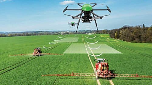
Sensors and digital imaging capabilities of drones give farmers a deeper insight in terms of irrigation problems, soil vibration, and pest cum fungal infections. Fig. 1 shows a drone helping in precision farming.
Why agricultural drone is important?
Here are some areas where drones can help in agriculture:
Plant monitoring. Drones with advanced special imaging called Normalised Difference Vegetation Index (NDVI) use detailed colour information to determine plant health. Drones monitor crop health regularly as compared to satellite imagery which is costly and not as effective in all weather conditions. As drones fly close to fields, cloud cover and poor light conditions matter less than when using satellite imaging. Satellite imaging may be accurate to a metre, but drone imaging is accurate to a millimetre. This means that after planting, areas with gaps can be spotted and replanted, and disease or pest problems can be detected and treated for right away.
Field condition monitoring. Drones can help monitor the health of soil and field conditions and detect all sorts of field irregularities.
Field spraying. Drone sprayers can navigate hard-to-reach areas such as steep tea fields at high elevations. Drone sprayers save workers from having to navigate fields with backpack sprayers, which can be hazardous to their health.
Security. Drone cameras can provide an overview of farm operations and equipment in the field, throughout the day, to ensure operations are running smoothly. Security drones can be deployed to monitor fencing and perimeters of more valuable crops like cannabis instead of employing more security personnel.
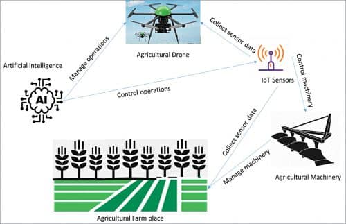
Artificial Intelligence
A drone technology in development involves machine learning. Improving artificial intelligence (AI) in drones is important to make them more useful to smaller farmers in developing nations. Current drone technologies are more effective in monitoring well-known crops like corn that are planted in large monocultural field patterns. Drone monitoring programs, as they stand, have a hard time recognising areas with increased crop diversity, less well-known produce, and grains which look similar throughout their growth stages, and so are less effective in monitoring such crop growth and their health.
Commercial drones
Companies such as DJI have developed customised models for crop protection against insects or weeds by carrying out the integration of specific sensors such as multispectral, high-precision RTK GPS, and high-resolution cameras. Parrot Bluegrass Fields is a complete drone solution having drone+multispectral sensor +processing software, ready to fly and suitable for the entire crop analysis workflow. Parrot Bluegrass Fields provides farmers with information to maximize their yield and improve the quality of their crops.
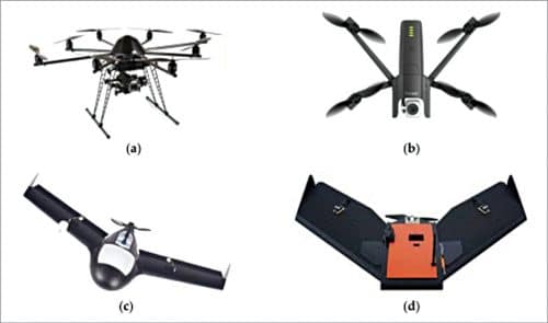
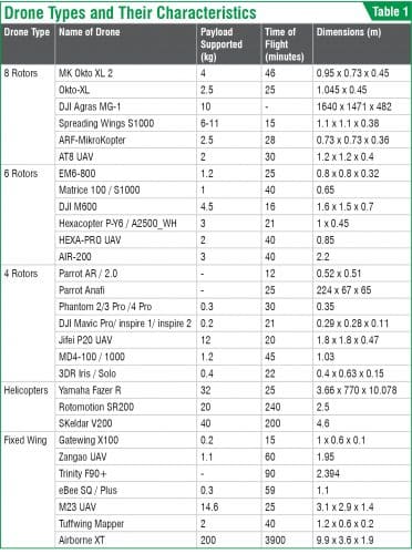
There is always a trade-off between endurance (maximum time of fight) and payload in drones. Thus, if endurance increases (by adding more powerful batteries or a higher capacity fuel tank), the payload decreases due to the increment in weight. Table 1 highlights some of the main drone types used in agriculture and their characteristics.
Sensors in agricultural drones
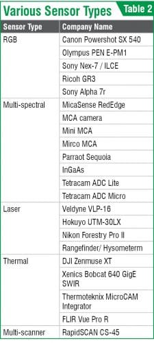
The reduction in weight and consumption of newer equipment and measurement instruments has made it possible to improve the drone sensors and therefore to expand their field of application. Table 2 highlights various sensors integrated with agricultural drones classified into RGB (visible spectrum) sensors, multi-spectral and hyperspectral cameras. In addition, drones also integrate laser, thermal, and multi-scanner sensors.
Top agricultural drones
Drones are made keeping their application in mind. Here are the top agricultural drones for 2021:
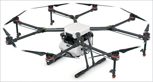
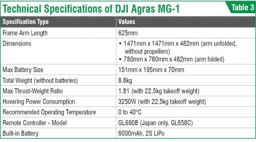
DJI Agras MG-1 for crop spraying
The Agras MG-1S from DJI integrates cutting-edge technologies including the newA3 flight controller and a radar sensing system that provides additional reliability during flight. The spraying system and flow sensor ensure accurate operations. When used with the MG Intelligent Operation Planning System and the DJI Agriculture Management Platform, a user can plan operations, manage flights in real time, and closely monitor aircraft operation. The MG-1S is a high-performance aircraft capable of offering comprehensive solutions for agricultural care.
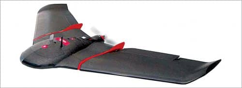
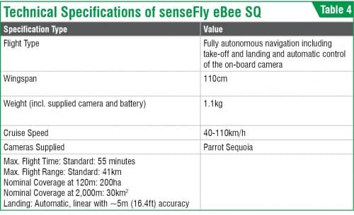
senseFly eBee SQ for overall agriculture use
senseFly eBee SQ is an advanced agricultural drone built around Parrot’s ground-breaking Sequoia camera. This fully integrated and highly precise multispectral sensor captures data across four non-visible bands, plus visible RGB imagery, in just one flight. With this precise data you can generate accurate index maps and use these to create high-quality prescriptions for carefully optimising crop treatments to improve production quality, increase yields, and reduce costs. The eBee SQ can cover hundreds of acres in a single flight—up to ten times more ground than quadcopter drones—for extremely efficient crop monitoring and analysis. This means fewer flights in total, far less time spent collecting data and more time acting on it.
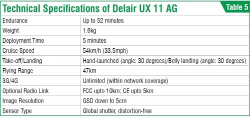
Delair UX 11 AG for agriculture mapping
The Delair UX11 AG is a plant mapping drone, allowing you to collect land aerial intelligence more accurately and efficiently. The drone is capable of onboard data processing and, with wireless and 3G/4G communications, allowing you to overlay maps for temporal analysis. Unlike the other drones, this is a fixed-wing drone, which means it is capable of flying longer distances and for longer periods of time (up to 50 minutes, across 47 kilometres). The drone carries a high-end multispectral camera for plant-level measures.
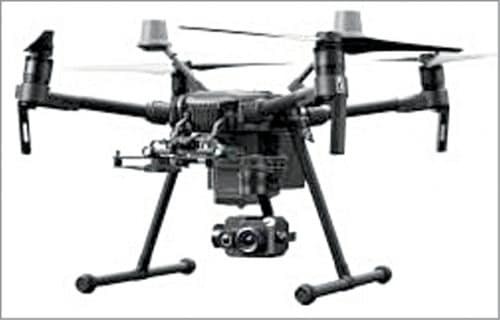
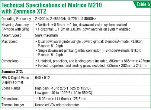
FLIR Matrice M210 with Zenmuse XT2 for thermal imaging
The Matrice M210 can carry large payloads, whether it’s a third-party sensor and cameras from multi-spectral to hyperspectral and full frame, or its own DJI Zenmuse XT2 dual thermal camera. The drone can be upgraded with DJI’s D-RTK GNSS system to allow for centimetre level hovering accuracy. It’s also compatible with DJI’s SDK, so users can control up to five aircraft simultaneously, making inspecting a large farmland more efficient than previously possible. The Zenmuse XT2 is also compatible with DJI’s M200 series, M200 series V2, and M600 Pro drones.
Dr Anand Nayyar is PhD in wireless sensor networks and swarms intelligence. He works at Duy Tan University, Vietnam. He loves to explore open source technologies, IoT, cloud computing, deep learning, and cyber security
Dr Magesh Kasthuri is a senior distinguished member of the technical staff and principal consultant at Wipro Ltd. This article expresses his views
and not that of Wipro