


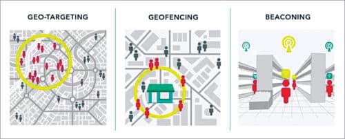
Geofencing, as the name suggests, is a location-based technology that creates a virtual boundary or fence. It is a feature in a software program that uses the global positioning system (GPS) or radio frequency identification (RFID) to define a virtual geographical boundary, establishing a radius of interest that can trigger an action in a geo-enabled phone or any other portable electronic device. It is a very useful technology to define a virtual boundary around a real-world geographical area, to generate alerts based on the defined coordinates of a geographic area.
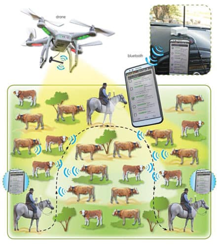
Geo-location technology allows mobile apps to do incredible things, and geofencing is the next step in this ground-breaking innovation. One of the first users of geofence were farmers who would equip a herd of cattle with GPS units. When the herd of cattle moved out of the geofence set by the farmer, the farmer would receive an alert.

Today, geofencing has moved from its expensive commercial use to the realm of consumer application and is widely being incorporated by developers and innovators into their hardware (smartphones, tablets, etc). There are a large number of applications that offer the benefits of geofencing to people like you and me.
As per a recent report from ABI Research, the market for geofencing tools currently stands at about $300 million. With low-cost developer tools becoming accessible, geofencing is coming to the forefront and moving beyond conventional location-based applications to form the backbone of a host of new applications and services.
In the past, geofencing tools have been tough to develop, costly to licence and known to have limited application areas. With location features now being present in almost all handset types and a host of geofencing tools available from a number of major players, geofencing is expected to soon become an integral part of our daily lives.
How it works
Geofencing allows us to set up automatic alert triggers when a device enters or exits the boundaries defined by the administrator. For example, if the geofence is a geographic virtual boundary surrounding a user’s house, an e-mail or text message is automatically triggered and sent to the user by a geofence-enabled app on the phone when his child with the cell phone enters this area.
It is possible to establish a geofence area around a neighbourhood and have alerts sent out on specified days. For example, alerts could be sent out by a collection company on days fixed for garbage collection as per the schedule entered in geofence-enabled app.
By incorporating Google Earth, administrators can define boundaries superimposed on top of a satellite view of a specific geographical area. Or, they can do this by longitude and latitude, or through user-created and web-based maps.
Geofence virtual barriers can be either active or passive. Active geofences require the end user to turn on location services and open a mobile app. Passive geofences are ‘always on,’ rely on Wi-Fi and cellular data instead of GPS or RFID, and quietly work in the background.
Geofencing software
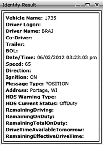
A good geofencing software is one that provides a host of information such as the exact location of the object, the time when it entered or exited the geofence, the time it spent at a particular position, and average time spent in travelling from and to a set position. It allows the user to set up a geographical limit as well as a time limit and a call for alert in case of any violation of rules. The zones and times applied can be varied for different objects and different days of the week, if required. The alert type can also be customised.
Geofencing software can be used by different people in a multitude of ways. For example, for a housing maintenance manager, it is important to know if all his vehicles are available on call inside boundaries of the city. Hence he can specify the boundary of the city as a mandatory zone between certain hours from Monday to Friday, or as required.
For insurance purposes, a transport manager needs to be sure that his trucks are parked in the depot overnight, not outside drivers’ homes. Therefore he can specify the location on the map and make it a mandatory zone for a specific time period. Breach of this zone would trigger an alert to the concerned official, preventing misuse of time and fuel.
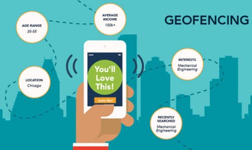
Geofencing in marketing
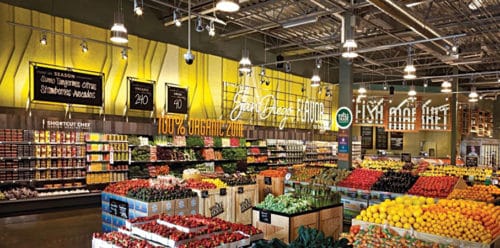
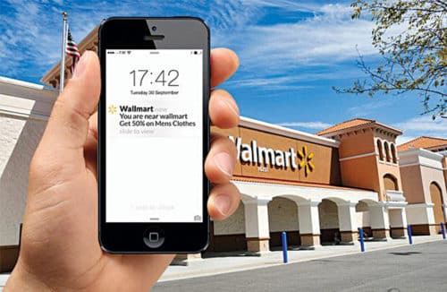
Geofencing helps to create a communicative interaction between a brand and its customers. It is useful for businesses to promote their brands, products or offers to enlarge the market size.One of the most common ways is to send special offers to customers when they walk or drive near a business location. For example, if you run a pizza shop and want to promote a new variety of pizza, you send out a geofence message inviting people to come in and taste the new recipe with a bottle of Coke. Or if you run a gym and want to launch a new health event or programme such as “Burn your belly fat,” geofence messages can be used to alert users and invite them to join the programme.
Thus geofence makes push notifications popular by making the mobile messaging timely, relevant and inordinate for customer engagement.
Geofence technology provides precision customer targeting with genuine, personalised messages. It provides multi-channel businesses an opportunity to interact with nearby customers through mobile devices, split-test customer engagement at every level and gain a deeper understanding of customers’ desires. It is a powerful tool to connect with new customers looking for your product as well as existing customers present in the area. Thus geofencing enables brick-and-mortar expansion of businesses.
Imagine you enter an area covered by geofence and are running a geofence app on your mobile device. You are looking for a good pair of wireless headphones and hence key-in some relevant search words such as wireless headphones. Within seconds you receive a message or notification and ads for in-store purchase of wireless headphones. You like the headphones, find the offer attractive and walk into the store to purchase the same.
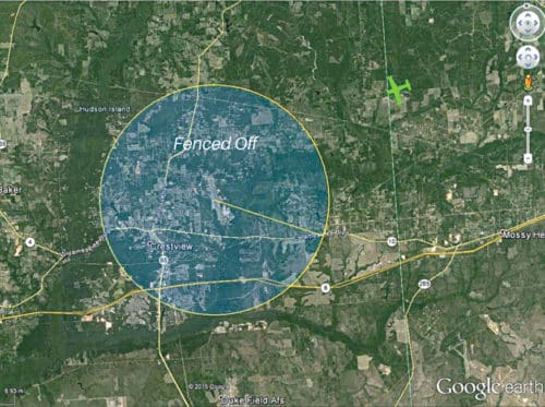
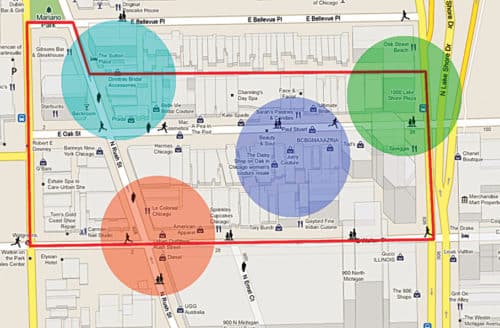
The fenced area could be as big as one km radius or just the walking distance in a mall. In rural areas, geofence is likely to cover a much wider area, given the lower population density.
The fence coordinates are hard-coded into the app. The app users get trigger notifications as they enter or exit the geofence area. The apps use various technologies to spot the change of location, most of which are generally Wi-Fi based.
Geofences are created using mapping software, which allow drawing of the geofence over the desired area using latitude and longitude coordinates or, in case of a circular geofence, a single point that forms the centre. The data can be obtained via a wireless connection, RFID and even GPS. A geofence has a fixed location and the object using GPS (a vehicle, equipment or person) is generally moving or is movable.
For a GPS-tracked object to work with a geofence, the following conditions need to be met:
1. Creation of a geofence using mapping/fleet management software
2. Ability of the GPS-tracked object to report its position (latitude/longitude) to the used software
3. Association of the tracked object with the mapping software
4. Establishment of a rule that triggers an alert when the tracked object enters (or leaves) the geofenced area
To avoid the problem of unnecessary multiple SMS being triggered just at geofencing border, often a buffer area is created around the geofencing border—say, 10 metres more in radius. When a user exits the geofencing border, an SMS is triggered. However, when the user enters the geofencing area and again exits, SMS is triggered only when the user travels the full 10 metres of buffer area within the geofencing boundary and then exits.
Also, one needs to be careful when using geofence for advertisement. Some people are likely to regard location tracking as something that bothers them and infringes on their privacy.
When integrated with CRM, geofence helps to collect useful data. You can add value to your app and your business as you are able to come up with something timely, relevant and useful. Your geofence messages are likely to improve your customers’ experience and not flagged as spams.
Other applications
Geofences can also be used to keep an eye on things (know if a vehicle or piece of equipment is removed from your yard) or to keep things out (for example, to keep vehicles out of a restricted area, or to keep mining workers out of an area where explosives are being used). Today, it is not easy to manage on-the-ground workforce. However, it can be streamlined with the help of route optimisation techniques and map-based real-time tracking.
Geofencing acts as a great facilitator. You can demarcate delivery fences and, by providing your workforce with smartphones, receive notifications every time a delivery goes off-track. Moreover, if delivery packages are equipped with RFID tags, these too can be tracked throughout the delivery process.
In case your business depends on collaborating with other local businesses, a geofence app based interface will make it possible for you to be aware of and communicate with local retailers, delivery warehouses as well as local operators. Thus geofencing facilitates expansion of a centralised business.
Another application is getting more out of your analytics program. When used in conjunction with location-based information, analytic data generates geofenced metrics. These enable you to understand behaviours like the time spent at various locations, purchase preferences, area preference and time spent on different kinds of shopping. You can even better understand the effectiveness of your promotional messages and accordingly fine-tune them.
Geofencing can also be useful in event organisation. Geofence becomes a virtual perimeter around a physical venue—perhaps a conference hall area in a hotel. It then communicates with app users (delegates) while they are inside it. By using their phones’ GPS locator and a transmitter such as iBeacon, conference organisers can help attendees who walk in through the door to smoothly check-in along with opt-in social media networking and directions to specific points of interest. The event-specific app will inform attendees whether a certain colleague is present at the same venue and even allow them to share contact details.
Participants at a tradeshow can stream demo videos to potential clients as they pass by their stall, or offer e-coupons to those who seem keenly interested. Such event-based apps also help to provide attendees with information on who is speaking, when and where.
Seamless two-way communication is also possible—for example, audience can key in questions for a speaker and send them off to be archived and answered when time permits.
Geofencing is being used to restrict firearms only to permitted areas, thereby rendering them unusable in restricted areas. In some firms, it is used by the human resource (HR) department to keep an eye on employees working in special locations, more so while on field duty. The geofencing tool enables employees to log their attendance with the help of a GPS-enabled device when within a designated perimeter.
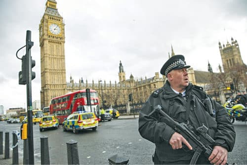
Countering terror attacks
Geofencing based systems are now increasingly attracting the attention of countries in fighting the menace of terrorism attacks. This technology has been found to be very effective in countering terrorism.
For example, the UK government is planning to install high-tech digital geofence fields around iconic buildings and bridges to prevent and counter sudden terror attacks using cars and vans to plough down pedestrians in busy areas. London witnessed three such attacks this year, including an attack on the Parliament in March, and at London Bridge and a mosque in Finsbury Park. The geofence systems being developed by the UK government rely on satellites to create electronic boundaries around specific sites.
Geofencing would help connect with on-board computers in vehicles to automatically slow them down to walking pace, or to block unauthorised vehicles from entering security-sensitive areas. If a driver tries to cross the electronic boundary, the system would connect with their on-board computer and limit the vehicle’s speed to a very safe level.
A UK company is working on such technology by using telematics, that is black box-style devices, to shut down a car or lorry when it has been hijacked. Sweden has already adapted the technology and vehicle manufacturers such as Scania and Volvo are in the process of conducting trials.
Similar technology is in use in drones to stop them from flying into restricted air space. It has also been proposed that government regulators should motivate drone manufacturers to factor in geofencing restrictions into unmanned aerial vehicle navigation systems that would overrule the instructions given by an unseasoned operator, thus avoiding flight into protected airspace.
What the future holds
Today, geofencing is being used in personal productivity management, smart home control, home security, family tracking, ‘if this then that’ systems and quite widely in commercial businesses. And the rapid development of technology promises even more in the future.
Work is going on to develop geofencing features that integrate the virtual environment with increasing accessibility of GPS technology, giving rise to new possibilities. For example, users can assign borders and fill colours when creating or editing a geofence. They can create as many geofences as they wish and colour-code the different fences. This enables the users to differentiate between the various geofenced areas more conveniently and speedily on the map.
The platform’s mapping functionality has also evolved—with the ability of a user to filter assets depending on asset status, alert status and within a last-reported range. This filtering allows the user to quickly screen out tracked assets that are not of interest at that time. This is a useful feature for users when, for example, they quickly want to see only those assets that are presently on the move or all assets that have a current alert.
We can expect developments in every sphere ranging from artificial intelligence (AI) for workstations to managing daily household tasks. As devices become more intelligent and more aspects of our home, automobiles and workplace enter the ever-growing fold of Internet-of-Things objects, we can look forward to seeing geofences applied to an increasing number of gadgets and environments.
This heightened integration is likely to result in all kinds of innovation such as desktops that switch off when their users leave for the day, tea kettles that switch on in the morning when the first tea drinkers arrive, soothing music that turns on to greet you as you arrive home, garage doors that open automatically as you reach close to home and more. Thus geofencing is likely to have a major impact on the way we work, play and live.