


First shown at CES 2016, Etos is a BMW i8 with an auto-pilot and a drone onboard. Frank M. Rinderknecht, boss of the Swiss creative think-tank Rinspeed, intends to use the UFO-esque drone on board Etos for performing services such as picking up deliveries from stores as the car drives you home, while you relax with a book in the driver’s seat. Drone applications have definitely gone way beyond their initial use as aerial torpedoes, unmanned weapons platforms and surveillance.
Financial benefits look very promising for developers of well-engineered drones. In a recent Forbes article by Baldwin Cunningham, it was said that the drone economy could be as incredible as the app economy we had seen in the last decade. To engineer drones that can handle next-generation applications, let us take a look at the technologies available for you.

Propulsion
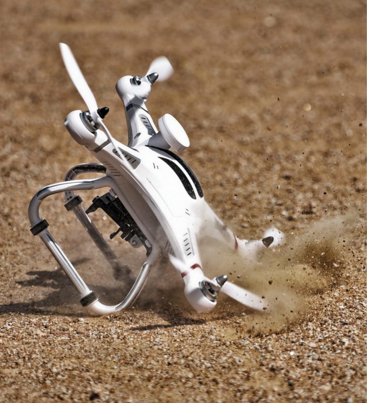 Before you try to put smarts into your drone, you need to get your drone off the ground. When you select your mix of motor and propeller, you need to make sure that there is enough thrust to comfortably pick up the entire drone.
As an example, a motor and propeller combination that delivers 500 grams of thrust in a quadcopter configuration would be able to barely lift a two-kilogram drone. This is not an ideal situation and so it is recommended that the weight of your drone be less than half the maximum thrust your configuration is capable of delivering.

Direct current (DC) brushless motors are the most commonly used ones here. The Kv rating you find in these motors signify revolutions per minute per volt. A motor rated at 1000Kv will spin 1000 times per volt when there is no load attached to it. This is just a theoretical value, so it is not recommended to test your brushless motor without a load on it. To control speed, you can increase or decrease the voltage applied to the motor.
Electronic speed controllers (ESCs) are devices that let you control revolutions per minute (rpm) of the motor reliably. These devices are able to handle the maximum current the motor might consume at the exact voltage as required by the user. Most motor manufacturers offer their own ESCs.
Some of the popular motors in the market are the ones by Lynxmotion, TMotor, DJI and Storm. You need not look at motor brands; you should be fine as long as the specifications match your rpm and thrust requirements. Some expensive motors we came across come with better ball bearings that promise longer life and more reliability. For example, MN3508 motor built for aerial-photography drones comes with ball bearings that are twice the standard size seen.
 However, electric motors come with an inherent weakness in the form of range and flight duration due to battery-pack limitations. That is where people have gotten creative to repurpose tried-and-tested technologies like internal combustion engines. Yeair is one such product that comes with a ten cubic centimetre combustion engine paired with running engine control. The result? A drone with a range of over 55 kilometres!
Trying to make some sense
Without proper input to the drone (or its pilot), your drone is not going to reliably fly anywhere. There is quite a wide range of sensors that you can choose from to allow your drone to make sense of its surroundings.
Can I see. Drones also stand to gain from technologies like Intel’s depth-sensing camera technology from 2014 called RealSense 3D, which has the potential to enable holographic navigation and real-time environment monitoring.
Sony’s Exmor R CMOS sensors are used in drones as these excel at recording in low-light conditions and are also able to record smoother action sequences while preventing smear from strong light sources such as streetlights.
DJI, the current king of consumer drones, uses Lightbridge technology that enables streaming video at 760p without latency to the pilot, while the drone itself records video at 1080p full-high-definition.
Drones like Inspire 1 can also shoot 4K videos and feature rotors that can be lifted out of the view of the drone’s camera, thus providing a 360-degree view. It is no surprise that this is the drone that lives onboard Etos car we mentioned earlier.
 Considering the rise in solar energy installations in India, drones designed to detect small defects on photovoltaic modules are a very good application. Existing drones can also be fitted with payloads for this application, by pairing an infrared (IR) camera like FLIR TAU 640 and AscTec IR RAW data logger that can be used with German AscTec Falcon 8 drone. Falcon 8, considering its use in critical applications, comes with flight-control systems and electronics that deliver three times redundancy.
Where am I. Vision positioning is another technology used by DJI drones that lets the drone have high hover accuracy by using ultrasonic sensors. This lets a drone hold its position without using a global positioning system (GPS). DJI’s Phantom drone also comes with FailSafe, which allows it to return back home in case it loses connection with the controller.
Intelligent orientation control allows easier control of the drone for the pilot as it considers forward direction of the drone to be forward direction of the pilot and not the direction in which the drone’s nose is pointing.
Newer drones have also taken the next step forward for positioning and have started to use Russian GLObal NAvigation Satellite System (GLONASS) in addition to American GPS. Integration of better navigation systems into newer drones has also allowed these to be set to fly to a particular location, capture footage and then return back home autonomously.
Am I intelligent. Talking about autonomous drones, Zano is the result of a very successful Kickstarter project that raised almost ` 230 million. Small enough to fit in the palm of your hand, Zano drone comes with a smart piloting system that lets beginners easily pilot the drone. It also features IR obstacle-avoidance as well as echo-sounding sonar and high-accuracy pressure sensors for better flight.
Drones meant for use by researchers take things a step ahead when it comes to flight systems. AscTec Firefly is designed with that application in mind and therefore comes with advanced sensor components and two ARM7 microprocessors. A low-level processor functions as the data controller and processes all sensor data and sensor-data fusion, while a high-level processor controls the flight system as per the control algorithms given to it. The inertial guidance system drives this drone’s autopilot with a 1000Hz update rate.
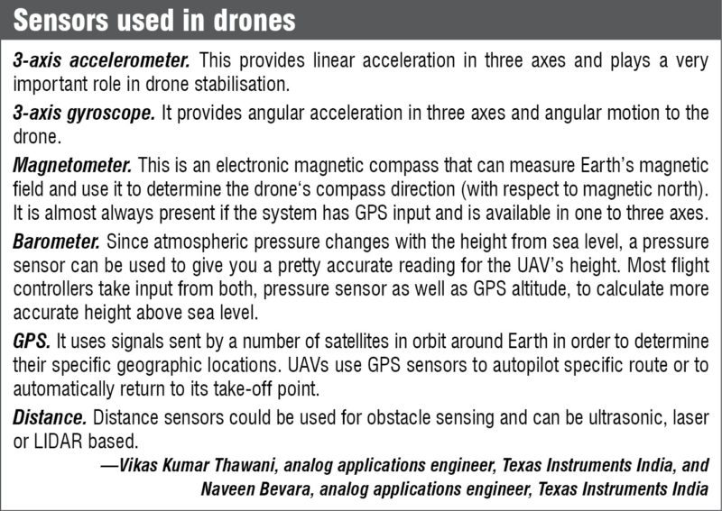
Hobbypower KK2.15 is an update of the popular HobbyKing KK2.0 flight controller board used by many beginner quadcopter builders. It houses InvenSense MPU-6050 MEMS motion-tracking device designed for low-power use cases.
MPU-6050 combines a 3-axis gyroscope and a 3-axis accelerometer with an onboard digital-motion processor to process 6-axis MotionFusion algorithms. The device can access external magnetometers or other sensors through an inter-integrated circuit bus, allowing it access to sensor data without intervention from the system processor.
Can I communicate. Botlink XRD (extended range and data) is an enclosed device that allows you to control your drone through the mobile network instead of using traditional radio or Wi-Fi. This technology allows beyond line-of-sight communication, data transfer and control through your mobile device using mobile telemetry technology that runs on 4G long term evolution (LTE) connections. It also allows serious mission planning by overlaying data of other manned and unmanned aircraft in the area, as well as marking any military or restricted airspace clearly. It also alerts you of adverse weather conditions.
These are especially useful since this technology enables drones to fly beyond the line-of-sight of the pilot. “I figured there has to be some kind of software that can give awareness, let a drone know about things like boundaries and weather,” says Shawn Muehler, COO of Botlink, to The New York Times.
While some drone makers now have dual-control capability that lets two users control a drone—one controls the flight and the other controls the camera—other drone makers like 3D Robotics enable their drones to be smart enough to take over the second role. You can either let the drone know the path that it has to follow while you take over the camera or you can let it lock onto the subject while you play around with the flight to get that perfect angle.
Opening a new frontier for consumers: the sky
 Better-engineered drones enabled by the latest technologies could easily be just the right ingredient to unleash creativity on a massive scale. If all these sensor packages and camera payloads are too boring for you, North Dakota in the USA has legalised drones armed with tasers, rubber bullets or sound canons. The race is now on to build one.
While surveillance and cinema drones are applications that have almost been done to death, there are many new challenges that a drone with the right tools can solve. Something that looks hopeless today could be the next revolutionary application—it all depends on what the engineer in you makes it to be.
Dilin Anand is a senior assistant editor at EFY. He is B.Tech from University of Calicut, currently pursuing MBA from Christ University, Bengaluru