A mapping system combines sonar and cameras to help underwater robots navigate, find objects, and create 3D maps when water blocks camera visibility.
Underwater robots could soon operate in murky waters thanks to a new mapping system developed by engineers at MIT and the Woods Hole Oceanographic Institution (WHOI). The technology enables autonomous underwater vehicles to navigate, identify objects, and build 3D maps even when sediment clouds block camera visibility.
The system, called Sonar-MASt3R, combines data from optical cameras and sonar sensors to create maps of underwater environments. Sonar provides a view of the surroundings when visibility is poor, helping vehicles detect obstacles and navigate. As the vehicle moves closer to an object, onboard cameras capture visual information that is integrated into the map.
In testing, the system mapped underwater environments under a range of visibility conditions. Even when water was clouded with sediment, Sonar-MASt3R generated 3D maps and resolved features at the centimeter scale. When cameras were unable to see through the murkiest water, sonar data still produced a map that allowed the robotic system to navigate and approach objects for inspection.
Researchers believe the technology could support ocean exploration, underwater infrastructure inspection and maintenance, construction projects, environmental monitoring, and deep-sea recovery missions where poor visibility often limits robotic operations.
The system was developed to address a challenge in underwater navigation. Optical cameras can capture images but perform poorly in dark or cloudy water. Sonar sensors, which use acoustic waves to measure the distance, depth, and shape of objects, work regardless of water clarity but provide less visual information.
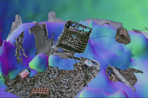
To evaluate the technology, researchers conducted experiments in a tank containing water, sediment, and various objects, including rocks, containers, and household items. A robotic arm equipped with an underwater camera and sonar sensor scanned the environment. The system first created a sonar-based map before capturing close-up images to add information.
The team tested the system under eight turbidity levels by stirring sediment into the water. Compared with other opti-acoustic fusion methods, Sonar-MASt3R produced more accurate maps in low-visibility conditions and maintained navigation capability even when camera visibility was limited.
The researchers are now preparing to test the system in natural underwater environments. They expect some aspects of sonar processing may become easier outside laboratory tanks, where confined spaces can create echoes and signal reflections. The technology was partly inspired by the challenge of locating and recovering unexploded underwater mines and other hazardous objects in low-visibility conditions.