


“Indian Regional Navigation Spacecraft System (IRNSS) is the Indian navigation system that envisages the establishment of the regional navigation system using a combination of geostationary orbit (GEO) and geosynchronous orbit (GSO) spacecraft,” reads Indian Space Research Organisation (ISRO) website on self-reliance with an indigenous navigation system.What does this mean for the common man?
We open Google Maps application on our phones and search for a place. The signal travels all around the world, to the GPS control station in the USA. Processing takes place at their end and, after some deliberation on their part, we receive certain co-ordinates. This takes some time.

Also, according to conspiracy theorists, security agencies get to know if you access anything disconcerting. With IRNSS, the time to access is expected to be much lesser and the said theorists can feel a bit safer, as this information will now be processed by Indian agencies.
Project timeline
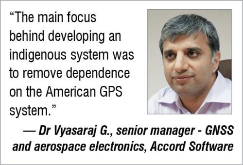
“It was back in 2003 that the project was beginning to take form,” recalls Dr Vyasaraj G., senior manager – GNSS and aerospace electronics, Accord Software. “The main focus behind developing an indigenous system was to remove dependence on the American GPS system.
After the announcement of the project we were to design simulators that could simulate the perfect environments for testing the satellites, and this began the race for development of IRNSS receiver modules.
“After finalisation of the systems, we had receiver modules being developed to test signal characteristics before the first satellite was in place. By the end of 2012, we had developed receiver modules, even before the satellites were launched,” adds Dr Vyasaraj.
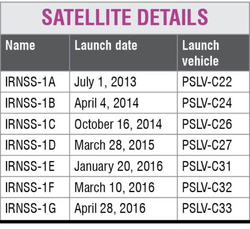
By 2008, project details were finalised and the expected date for the system to go live was set to end of 2015, with the first satellite being launched in 2011, and the next every six months. After a delay in the original timeline, the first satellite, IRNSS-1A, was launched on July 1, 2013, and the others followed suit. The last satellite, IRNSS-1G, was successfully launched on April 28, 2016, from Satish Dhawan Space Centre (SDSC), SHAR, Sriharikota launch site.
Development and deployment
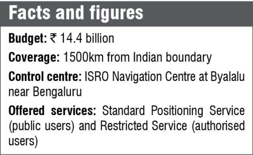
The proposed system consists of a constellation of seven satellites and a support ground segment. Three satellites are located in GEO and the other four in inclined GSO. Such an arrangement means continuous radio visibility at all hours for Indian control stations.
 “We typically have two signal frequencies to overcome the problem caused by disruption in the signal, which is caused by the ionosphere. This increases the size of the module due to the integration of two separate antennae for the two frequencies. Hence, a solution is to use a single antenna, meaning, a single frequency being used for navigation. Using a single antenna causes very low accuracy and can show a position difference by 10 metres to 15 metres.
“Addition of a second signal reduces this to about five metres to eight metres. Hence, a system integrator could decide on designing the system to reduce system complexity with a single antenna system for low-accuracy needs or placing two antennae for high-accuracy needs,” says Dr Vyasaraj on using multiple-frequency signals for location tracking.
He adds, “IRNSS systems have been working on adding L1 band for navigation. And very soon we may have three signals to further improve location accuracy for navigation systems.” The system uses grid-based ionosphere-related corrections for single-frequency users (L5/S) to improve location accuracy.
Testing and development
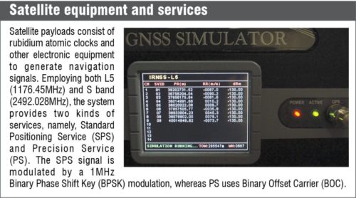
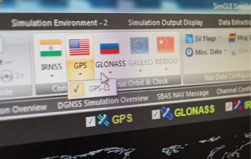
Before completion and launch of satellites, there is the need for testing the design parameters and the functioning modules. Design simulators have helped play a huge role in this stage of the development. “We have a simulator from Accord Software capable of generating and measuring signal conditions upon reception. The device hardware is compatible with American GPS, Russian GLONASS, Indian IRNSS, European Galileo and Chinese Bie-Deu/BDS.
“The simulator also has support for several SBAS systems. We can modulate and test signal parameters during various stages of transmission. The simulator generates signal distortions similar to the actual conditions and gives results, which can help fine-tune GNSS equipment,” says Dr Pratibha B.A., project leader at Accord Software.
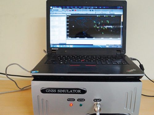
For field-testing purposes, there is a portable version of the device, which has an RJ45 interface for connecting to a computer system. The device can be controlled by a computer application loaded with custom firmware. The portable simulator has the same features as the other device with the added benefit of a compact design.
Along with simulators, development of an IRNSS-compatible receiver is also underway. G3I, a credit-card-sized receiver chip, with support for IRNSS along with other constellations, is currently under development.
Equipment and the challenges
“At present, IRNSS is not common in the market, which is going to change in the coming years.Complete testing and finalisation of the constellation should be done in the next six months and then we should see more IRNSS chips in the market,” says Dr Vyasaraj. After the launch of IRNSS-1G in April, dependence and test cases for the constellation are being run in earnest. Hopefully, in the next few months the system will open for public use.
The challenge when designing the receiver is to keep in mind the form factor along with support for other GNSS systems. “Any manufacturer who has successfully stayed in the market has done so by adopting and developing the latest patterns. Reducing the form factor to the level of wearables while improving accuracy and keeping latest updated support, and reducing cost mechanics, are some of the factors that keep a manufacturer in the market,” according to Dr Vyasaraj.
At present, we have a comparatively large chip for IRNSS receivers where the entire module is tablet-sized. Reduction in chip size with support for other constellations is expected in the near future.
Reducing the chip size
A major deterrent with current chips is the size. With reduction in size compatible with wearables, we have hopes for a more compact system. Let us take a look at how this miniaturisation could happen.
Majority of GNSS modules employ two distinct frequencies to overcome the errors in the received signals due to interference by the ionosphere. With only a single frequency, the difference is of a few metres, which is not an issue with wearables or end users.
On a day-to-day basis, we should be able to track a device to a particular building or a particular street, which can be easily done with the help of a single antenna/frequency module, thus reducing the space required on the module for the other antenna.
With grid based ionosphere corrections, this is significantly reduced. Additionally, Dr Vyasaraj points out, “When we are inside a room, we do not require such high precision as provided by the double antennae system. Here, we can go for the single antenna system and reduce cost and size of the modules”.
Other ways to miniaturise the chipset could come up in the near future so that integration is easily possible into a smartphone or a wearable gadget.
What the IRNSS system looks like
 IRNSS system blankets the South Asian region, with more frequent updates compared to earlier systems. The precise and faster location in real-time, along with the atomic clock on-board the satellite providing higher timing accuracy, provides a major boost to high-accuracy requirement applications.
With the added feature of grid based ionosphere-related corrections for removing issues caused due to interference by the ionosphere, this system is at par with GPS+WAAS, Galileo+EGNOS and MSAS systems around the world.
Tracing the track ahead
 IRNSS is at present in the deployment phase. With heavy R&D in the field of an IRNSS-compatible chip miniaturisation, we will see some excellent IRNSS receiver modules in the coming years. “It will take about two years for the system to be widely popular with the end user. Till then we will see a lot of developments in the area, and by the time the market demand for IRNSS-compatible products increases, we will have a very wide array of products,” adds Dr Vyasaraj.
Development of IRNSS will be an added advantage to the Indian defence systems in preventing another Kargil-like fiasco. With Make in India initiative, development of such chips will take priority, and we will have many indigenous products to work with in the years to come.