

The new drone navigation system uses star-based positioning instead of GPS, making navigating in remote or GPS-denied areas possible. Find out more!
In collaboration with the Defence Science and Technology Group, researchers from the University of South Australia have developed a solution for drone navigation when Global Navigation Satellite System (GNSS) signals are unavailable. This method is reminiscent of ancient maritime navigation, which used the stars to determine location.

The team highlighted the technology’s value for environmental monitoring in remote areas or long-endurance surveillance missions where GPS might be unavailable or compromised. It was noted that GNSS denial is an increasing challenge, and the research addresses this gap. The developed navigation method is resilient, independent of external signals, and achievable with low-cost, easily accessible components. This makes the technology applicable to various UAVs, from commercial drones to advanced defence applications.
When GNSS systems such as GPS are unavailable — due to failure, atmospheric conditions, or jamming and spoofing attacks — drones and other unmanned vehicles require a dependable navigation method. The team’s solution is to look to the sky, navigating by the stars, much like sailors once did with a sextant.
The research claims that unlike traditional star-based navigation systems, which tend to be complex, heavy, and expensive, their system is simpler, lighter, and does not require stabilisation hardware, making it suitable for smaller drones. This type of navigation is particularly well-suited for operations over oceans or in conflict zones where GPS jamming is a threat. In addition to its military applications, it could also prove highly valuable for environmental monitoring.
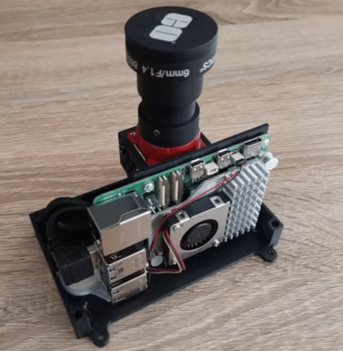
The prototype navigation system uses an ArduPilot Cube Orange flight controller connected to a Raspberry Pi 5 single-board computer and an Alvium 1800 U-240 monochrome image sensor. It can position a drone within 4 km (about 2.5 miles) — less precise than GNSS but accessible wherever the stars are visible. The system flies in fixed orbits until a location fix is established.
The researchers found through field experiments with a fixed-wing drone that the algorithm is robust against initial conditions. It requires no prior position knowledge and only needs the camera to be aligned within a hemisphere of tolerance.