

Indian universities developed and launched several microsatellites (microsats) between 2009 and 2011, in association with the Indian Space Research Organisation (ISRO). These were amongst the first few microsats in space. While these were successful experiments that gave wings to academic dreams, microsats are now being viewed with greater expectations. These mini space wonders might work their magic beyond the field of science and technology and shake up the business world as well, much on the lines of GPS and location-based services.

“The term microsatellite is generally used for satellites in the range of 10 to 100 kg. Today, satellites generally weigh 1000 to 5000 kg,” explains D. John, former deputy director, Satellite Communication Programme and deputy programme director, EDUSAT, ISRO headquarters, Bengaluru. Microsatellites are not only low in weight, but are also smaller and cost less than regular satellites. This enables them to be sent into space using launch vehicles or by piggybacking on rockets with excess capacity. Plus, due to their comparative simplicity, it also becomes possible to build and launch a fleet or constellation of such satellites, which might be used jointly as a communication or imagery system. Such a system will be capable of grabbing and updating images much faster than traditional satellites, due to the large number of satellites per constellation.
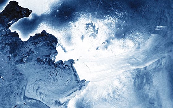
Imagine such constellations of microsats, launched and maintained by private companies, and leased out to businesses or research organisations. It would be possible to know in near real-time about events related to maritime movements, border security, forest fires, migratory birds, traffic situations, diversions, the status of crops, weather changes, map updates, or even the movement of a fleet of trucks, without requiring RFID tags or any cumbersome set-ups!
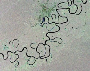
According to Timothy Edgar, visiting fellow, Watson Institute for International Studies, Brown University, USA, “Microsatellites would allow companies, smaller governments or small government entities like state, provincial or local governments, to use overhead imagery with greater resolution and frequency than is typically available today on the commercial satellite imagery market, such as what consumers see with Google Maps. Traditionally, these more powerful images, frequently updated, have been available only to the militaries and intelligence services of major powers. They can be used for military applications and intelligence analysis, and for any number of peaceful purposes such as fighting forest fires, analysing crowds in natural disasters or public emergencies and assisting in law enforcement.” He adds, “The number of microsatellites in space could grow quite quickly, as new companies find ways to exploit such imagery. There could be any number of surprising uses, from real estate (commercial and residential) and parking management to corporate security.”
So the new meaning of SaaS could soon be ‘satellites as a service!’
Smartphones, tablets and, now, satellites
Moore’s Law has had its repercussions in more fields than one. As more and more transistors get packed into integrated circuits (ICs), and the chips get increasingly powerful, it is becoming possible to build more powerful yet smaller devices. What computers could do some years ago, smartphones are now able to do with ease.
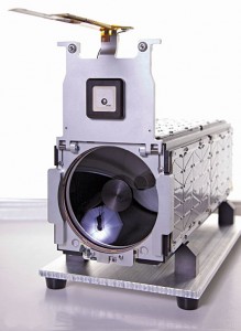
Satellite technology is one such beneficiary of advanced ICs. Robbie Schingler, co-founder of Planet Labs, a US-based company, says, “The microsatellite industry benefits greatly from the exponential advances in computing and the increased miniaturisation of consumer electronics. We are piggybacking on decades of research and development in these fields. If you think about what a satellite is, many of the components are that of a supercomputer. The key components of our microsatellite include communication systems (radio, etc), the optics (for imaging), the power system (battery, etc), and the onboard software and computing systems. Our satellites are essentially remote-sensing robots in space, with superfast processors.”
“The use of commercial off-the-shelf (COTS) components has been instrumental in the growth of the microsat industry. During the earlier days of satellite building, components were selected, laboriously space-qualified and tested before they were allowed to be used by quality assurance experts, thus pushing the cost high. Digital ICs were ruggedised by shielding them against radiation in space. Today’s components are developed to ensure higher reliability. This fact, coupled with the COTS approach, has resulted in the shift towards microsatellites,” says John, who was earlier with ISRO. However, he remarks that space-qualified microcontrollers and processors with high processing power are still not readily available, resulting in prohibitively high costs.
Digital IC technology is developing so fast that even nano, pico and femto satellites have become possible. Nanosats weigh between 1 and 10 kg, while pico and femto microsats have wet masses of 0.1 to 1 kg and 10 to 100 gm, respectively.